New school boundaries 2020
Following the State Government's announcement of a new local intake secondary school in Subiaco, the local intake area for our school has been amended.
Our amended local intake area will come into effect in 2020 when Inner City College (planning name) in Subiaco opens. All children enrolled at our school in 2019 will be able to complete their schooling here. They will not have to change schools. Additionally, if you currently live our school's local intake area and, with the changes, you will live in a new local intake area you will have the choice to enrol your children at our school or your new local intake school. Further information on new local intake areas is on the Department's website at education.wa.edu.au.
View enlarged Intake Map 1 depicting intake area 2017 to 2019
View enlarged Intake Map 2 defines the local-intake area of this school from 2020:

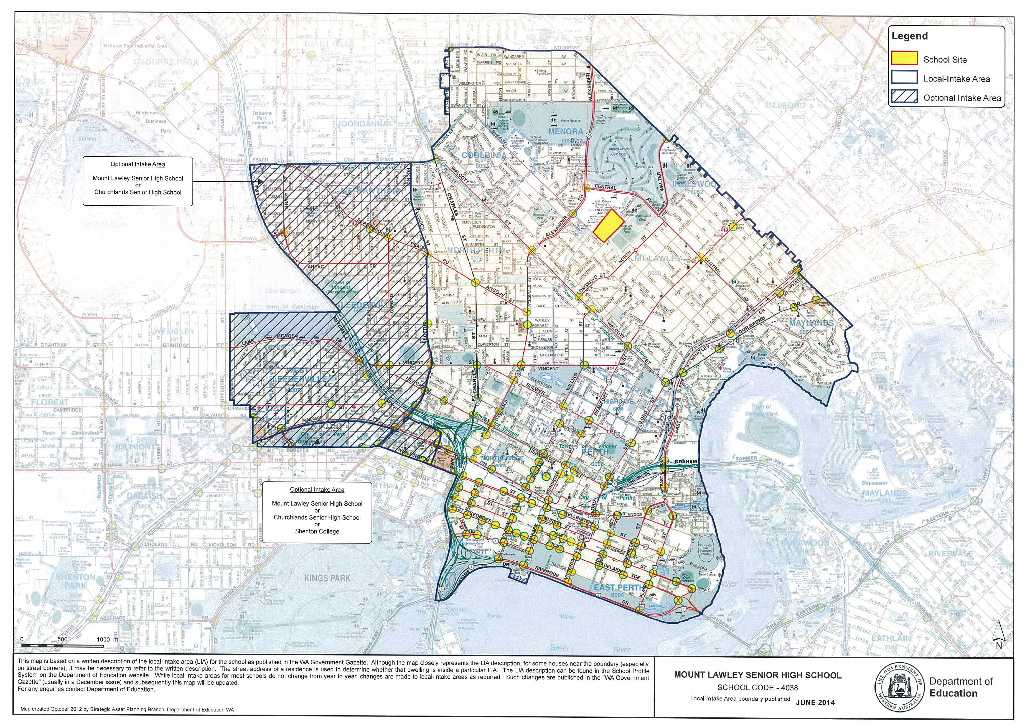
The following defines the local-intake area of this school for 2017 to 2019:
From the junction of Wanneroo Road and Wiluna Street, north-east along Wiluna Street (south east side included) to Flinders Street, north along Flinders Street (both sides included) to Blythe Avenue, east along Blythe Avenue (south side included) and Woodrow Avenue (south side included) to Cresswell Road, south-east along the extension of Cresswell Road (south west side included), Homer Street (south west side included), Dundas Road (both sides included), Eleventh Avenue (both sides included) to York Street, north east along York Street (east side included) to Kennedy Street, south east along Kennedy Street (both sides included) to the railway line, south-west along the railway line to Caledonian Avenue, south-east along Caledonian Avenue (south west side included) to Joseph Street, south along Joseph Street (west side included) to Peninsula Road, east along Peninsula Road (both sides excluded) to Fogerthorpe Crescent, south along Fogerthorpe Crescent (both sides excluded) and its extension to the Swan River foreshore, west, south-west and west along the Swan River foreshore to the Narrows Bridge, north along the Mitchell Freeway to Wellington Street, west along Wellington Street to Sutherland Street, north and north west along Sutherland Street to Troode Street, west along Troode Street (both sides excluded) to Colin Place, north along Colin Place (both sides excluded) and its northern extension to Loftus Street, north along Loftus Street (east side included) to London Street, continuing north along London Street (east side included) to Green Street, east along Green Street (south side included) to Wanneroo Road and north along Wanneroo Road (east side included) to Wiluna Street.
The following defines an optional area between Churchlands SHS and Mount Lawley SHS:
From the intersection of the Mitchell Freeway and Scarborough Beach Road, east along Scarborough Beach road (south side included) to Green Street, continuing east along Green Street (south side included) to London Street, south along London Street (west side included) to Loftus Street, south along Loftus Street (west side included) to the northern extension of Colin Place, south along this extension and south along Colin Place (both sides included) to Troode Street, east along Troode Street (both sides included) to Sutherland Street, south east and south along Sutherland Street (southern and western sides included) to Wellington Street, west along Wellington Street (north side included) to Thomas Street, north east along Thomas Street (east side included) to the Perth-Fremantle railway line, generally west along the railway line to the Subiaco Railway Station, west from the railway station to Station Street (southern and northern sections, east side included), north along Station Street (southern section) to Salvado Road, west along Salvado Road (north side included) to Station Street (northern section), north along Station Street (northern section) to Cambridge Street, west along Cambridge Street (north side included) to Gregory Street, north along Gregory Street (both sides excluded) to the junction with Wise Street, east from this junction through Lake Monger to the Mitchell Freeway, north west along the Mitchell Freeway (north east side included) to Scarborough Beach Road.
The following defines an optional area between Churchlands Senior High School, Mount Lawley Senior High School and Shenton College:
From the junction of Roberts Road and Rokeby Road, north to the Subiaco Railway Station, north east and east along the railway line to Loftus Street, south west along Loftus Street (west side included) and Thomas Street (west side included) to Roberts Road, and west along Roberts Road (north side included) to Rokeby Road.
Local-intake area from 2020
MOUNT LAWLEY SENIOR HIGH SCHOOL (June17)
The following will define the local-intake area of this school from 2020:
From the junction of Wanneroo Road and Wiluna Street, north east along Wiluna Street (south east side included) to Flinders Street, north along Flinders Street (both sides included) to Blythe Avenue, east along Blythe Avenue (south side included) and Woodrow Avenue (south side included) to Cresswell Road, south-east along the extension of Cresswell Road (south west side included), Homer Street (south west side included), Dundas Road (both sides included), Eleventh Avenue (both sides included) to York Street, north east along York Street (east side included) to Kennedy Street, south east along Kennedy Street (both sides included) to the railway line, south-west along the railway line to Caledonian Avenue, south-east along Caledonian Avenue (south west side included) to Joseph Street, south along Joseph Street (west side included) to Peninsula Road, east along Peninsula Road (both sides excluded) to Fogerthorpe Crescent, south along Fogerthorpe Crescent (both sides excluded) and its extension to the Swan River foreshore, west, south-west and west along the Swan River foreshore to the Windan Bridge and the Graham Farmer Freeway, west along the Graham Farmer Freeway (north side included) to the junction of Newcastle Street and Lord Street, north west along Newcastle Street (north east side included) to Loftus Street, north along Loftus Street (east side included) to the intersection of Loftus Street, Scarborough Beach Road and London Street, north along London Street (east side included) to Green Street, east along Green Street (south side included) to the junction with Charles Street, north along Charles Street (east side included) to Wanneroo Road and north along Wanneroo Road (east side included) to Wiluna Street.
Note: All families with children currently living in the existing local intake area for Mount Lawley Senior High School will have the choice for their children to attend either their current local intake school or their new local intake area school (if it has changed) from 2020.
The local-intake area maps are based on a written description of the local-intake area (LIA) for the school as published in the WA Government Gazette. Although the map closely represents the LIA description, for some houses near the boundary (especially on street corners), it may be necessary to refer to the written description. The street address of a residence is used to determine whether that dwelling is inside a particular LIA. While local-intake areas for most schools do not change from year to year, changes may be made to local-intake areas as required. Such changes are published in the WA Government Gazette and subsequently the local-intake area map will be updated.